UNCLASSIFIED
PE 1203269SF: GPS III Follow-On (GPS IIIF)
UNCLASSIFIED
Air Force Page 1 of 8 R-1 Line #12
Exhibit R-2, RDT&E Budget Item Justification: PB2021Air Force
Date: February 2020
Appropriation/Budget Activity
3620F: Research, Development, Test & Evaluation, Space Force / BA 5:
System Development & Demonstration (SDD)
R-1 Program Element (Number/Name)
PE 1203269SF / GPS III Follow-On (GPS IIIF)
COST ($ in Millions)
Prior
Years FY 2019 FY 2020
FY 2021
Base
FY 2021
OCO
FY 2021
Total FY 2022 FY 2023 FY 2024 FY 2025
Cost To
Complete
Total
Cost
Total Program Element
0.000 0.000 0.000 263.496 0.000 263.496 267.542 294.706 286.279 177.074 1,182.166 2,471.263
653170: GPS IIIF
0.000 0.000 0.000 263.496 0.000 263.496 267.542 294.706 286.279 177.074 1,182.166 2,471.263
Quantity of RDT&E Articles - 2 - - - - - - - -
Program MDAP/MAIS Code: 590
A. Mission Description and Budget Item Justification
In FY 2021, PE 1203269F, GPS III Follow-On (GPS IIIF) efforts were transferred to Appropriation 3620, Research, Development, Test & Evaluation, Space Force, PE
1203269SF, GPS III Follow-On (GPS IIIF) from Appropriation 3600, Budget Activity 05 due to the creation of a new Appropriation for Space Force.
The Global Positioning System (GPS) is a space-based navigation system that fills validated Joint Service requirements for worldwide, accurate, common grid three-
dimensional positioning/navigation for military aircraft, ships, and ground personnel. The consistent accuracy, unaffected by location or weather and available in real
time, significantly improves effectiveness of reconnaissance, weapons delivery, mine countermeasures and rapid deployment for all services. GPS must comply with
Title 10 United States Code (USC) Sec. 2281, which requires that the Secretary of Defense ensures the continued sustainment and operation of GPS for military and
civilian purposes, and 51 USC Sec. 50112, which requires that GPS complies with certain standards and facilitates international cooperation.
The system is composed of three segments: User Equipment (funded under Program Element (PE) 1203164F), Space (funded under PE 1203265F, 1203165F, and
1203269F), and a Control Network (funded under PE 1206423F and 1203165F). The satellites broadcast high-accuracy data using precisely synchronized signals that
are received and processed by user equipment installed in military platforms. The user equipment computes the platform position and velocity and provides steering
vectors to target locations or navigation waypoints. The control segment provides daily updates to the navigation messages broadcast from the satellites to maintain
system precision in three dimensions to 16 meters (spherical error probable) worldwide. Additionally, GPS supports the United States Nuclear Detonation (NUDET)
Detection System (USNDS) mission and provides strategic and tactical support to the following Department of Defense (DoD) missions: Joint Operations by providing
capabilities for Positioning, Navigation, and Timing (PNT); Command, Control, Communications, and Intelligence (C3I); Special Operations; Military Operations in Urban
Terrain (MOUT); Defense-Wide Mission Support (DWMS); Air Mobility; and Space Launch Orbital Support.
GPS IIIF delivers GPS III satellites beyond the first ten Space Vehicles (SVs) being delivered by the GPS III program (funded in PE 1203265F GPS III Space Segment).
The GPS IIIF satellites maintain the same capabilities as the GPS III satellites, but also delivers significant enhancements to include: potential on-ramping of advanced
PNT technology from efforts such as NTS-3, backward compatibility, unified S-Band (USB) interface compliance, integration of hosted payloads including a redesigned
USNDS payload, Laser Retro-reflector Arrays (LRAs), Search and Rescue/GPS (SAR/GPS), Energetic Charged Particles (ECP) sensor, and Regional Military Protection
(RMP) capabilities that provide the ability to deliver high-power regional Military Code (M-Code) signals in specific areas of intended effect. Implementation of RMP into
the GPS Enterprise requires integration with the ground and user segments, executed by the GPS Next Generation Operational Control System (OCX), along with the
Military GPS User Equipment (MGUE) programs, respectively. The SAR/GPS payload provided by Canada fills a validated National Search and Rescue Committee
requirement to provide enduring, space-based distress alerting capability to detect, locate, and relay distress alerts to fulfill its responsibilities under international
Volume 1 - 97

UNCLASSIFIED
PE 1203269SF: GPS III Follow-On (GPS IIIF)
UNCLASSIFIED
Air Force Page 2 of 8 R-1 Line #12
Exhibit R-2, RDT&E Budget Item Justification: PB2021Air Force
Date: February 2020
Appropriation/Budget Activity
3620F: Research, Development, Test & Evaluation, Space Force / BA 5:
System Development & Demonstration (SDD)
R-1 Program Element (Number/Name)
PE 1203269SF / GPS III Follow-On (GPS IIIF)
agreements for Search and Rescue. LRA, built by the Naval Research Lab (NRL), is a passive reflector that improves accuracy and provides better ephemeris data.
National Geospatial-Intelligence Agency (NGA) funds the integration costs of the LRA.
This PE funds the Research, Development, Test, and Evaluation (RDT&E) of GPS IIIF SVs 11-12 (to include Non-Recurring Engineering (NRE) support efforts). This
program includes risk-reducing simulators and systems engineering associated with delivering the new capabilities required of GPS IIIF satellites.
Space acquisition must respond with speed and agility to emerging adversary threats. Space & Missile Systems Center (SMC) is transforming the organization and
implementation of space acquisition to an enterprise approach, maximizing innovation and resiliency, leveraging international, commercial, and mission partnerships,
and managing program/project priorities according to an integrated unclassified/classified enterprise space architecture. Expanding the appropriate acquisition
authorities and contract mechanisms to deliver capability sooner, SMC will strategically execute experimentation, prototyping, risk reduction, and other efforts to develop
new or repurpose capabilities.
The FY 2021 funding request was reduced by $15.835 million to account for the availability of prior year execution balances
This PE may include necessary civilian pay expenses required to manage, execute, and deliver GPS IIIF Space Segment weapon system capability. The use of such
program funds would be in addition to the civilian pay expenses budgeted in PEs 1206392SF and 1206398SF.
This program is in Budget Activity 5, System Development and Demonstration (SDD) because it has passed Milestone B approval and is conducting engineering and
manufacturing development tasks aimed at meeting validated requirements prior to full rate production.
B. Program Change Summary ($ in Millions)
FY 2019 FY 2020 FY 2021 Base FY 2021 OCO FY 2021 Total
Previous President's Budget 0.000 0.000 0.000 0.000 0.000
Current President's Budget 0.000 0.000 263.496 0.000 263.496
Total Adjustments 0.000 0.000 263.496 0.000 263.496
• Congressional General Reductions 0.000 0.000
• Congressional Directed Reductions 0.000 0.000
• Congressional Rescissions 0.000 0.000
• Congressional Adds 0.000 0.000
• Congressional Directed Transfers 0.000 0.000
• Reprogrammings 0.000 0.000
• SBIR/STTR Transfer 0.000 0.000
• Other Adjustments 0.000 0.000 263.496 0.000 263.496
Change Summary Explanation
FY 2021: +$263.496M; funds starting in FY 2021 were transferred from RDT&E, Air Force to RDT&E, Space Force.
Volume 1 - 98
UNCLASSIFIED
PE 1203269SF: GPS III Follow-On (GPS IIIF)
UNCLASSIFIED
Air Force Page 3 of 8 R-1 Line #12
Exhibit R-2, RDT&E Budget Item Justification: PB2021Air Force
Date: February 2020
Appropriation/Budget Activity
3620F: Research, Development, Test & Evaluation, Space Force / BA 5:
System Development & Demonstration (SDD)
R-1 Program Element (Number/Name)
PE 1203269SF / GPS III Follow-On (GPS IIIF)
C. Accomplishments/Planned Programs ($ in Millions)
FY 2019 FY 2020 FY 2021
Title: GPS III Follow-On (GPS IIIF) Development
Description: The program utilizes RDT&E funds to develop and deliver SVs 11-12, conduct the NRE of developing risk-reducing
simulators, developing support test equipment, and conducting the systems engineering associated with delivering the new
capabilities required of GPS IIIF including backward compatibility, dual band Telemetry, Tracking, and Control (TT&C), integration
of Government Furnished Equipment (GFE) hosted payloads, and RMP, which delivers high power regional M-Code signals in
specific areas of intended effect.
FY 2020 Plans:
N/A
FY 2021 Plans:
Continue development and NRE efforts to simultaneously support three satellites (SV11, SV12, & GNST+) in preparation for
the start of system integration and the final build and checkout of two software simulators (GSS). Efforts include hardware
purchases of long lead items. Rapidly respond to implement system resiliency and situational awareness necessary to operate
in the contested space domain. Activities may include, but are not limited to, continued program office support, studies, technical
analysis, experimentation, prototyping, etc.
FY 2020 to FY 2021 Increase/Decrease Statement:
N/A
0.000 0.000 263.496
Accomplishments/Planned Programs Subtotals
0.000 0.000 263.496
D. Other Program Funding Summary ($ in Millions)
Line Item FY 2019 FY 2020
FY 2021
Base
FY 2021
OCO
FY 2021
Total FY 2022 FY 2023 FY 2024 FY 2025
Cost To
Complete Total Cost
• SPAF 01 GPS03C:
GPSIII Follow On
- 394.625 - - - - - - - 0.000 394.625
• SPSF 01 GPS03C:
GPSIII Follow On
- - 627.796 - 627.796 634.821 640.782 920.657 750.853 3,230.317 6,805.226
• RDTE 07 1203265F:
GPS III Space Segment
72.096 42.440 - - - - - - - 0.000 114.536
• RDTE 07 1203265SF:
GPS III Space Segment
- - 10.777 - 10.777 7.296 1.598 3.382 7.722 0.000 65.493
• SPAF 01 GPSIII: GPS
III Space Segment
69.386 31.466 - - - - - - - 0.000 100.852
Volume 1 - 99
UNCLASSIFIED
PE 1203269SF: GPS III Follow-On (GPS IIIF)
UNCLASSIFIED
Air Force Page 4 of 8 R-1 Line #12
Exhibit R-2, RDT&E Budget Item Justification: PB2021Air Force
Date: February 2020
Appropriation/Budget Activity
3620F: Research, Development, Test & Evaluation, Space Force / BA 5:
System Development & Demonstration (SDD)
R-1 Program Element (Number/Name)
PE 1203269SF / GPS III Follow-On (GPS IIIF)
D. Other Program Funding Summary ($ in Millions)
Line Item FY 2019 FY 2020
FY 2021
Base
FY 2021
OCO
FY 2021
Total FY 2022 FY 2023 FY 2024 FY 2025
Cost To
Complete Total Cost
• SPSF 01 GPSIII: GPS
III Space Segment
- - 20.122 - 20.122 21.302 19.312 7.868 1.883 15.196 85.683
Remarks
E. Acquisition Strategy
In December 2017, Principal Deputy Office of the Assistant Secretary of the Air Force (Acquisition & Logistics) declared the GPS IIIF program a new start beginning
in FY 2019 and, consistent with the Fiscal Year 2016 National Defense Authorization Act (NDAA), the program was categorized as an Acquisition Category (ACAT)
(1B) Major Defense Acquisition Program (MDAP) with the Service Acquisition Executive (SAE) serving as the Milestone Decision Authority (MDA). During this time,
the MDA approved the second phase of the two-phased GPS III Follow-On acquisition strategy. Executed using funds in PE 1203265F, GPS III Space Segment, the
Phase 1 Production Readiness Feasibility Assessments conducted during FY 2016-2017 provided data and insight into contractors' GPS satellite production designs
with emphasis on a mature navigation payload and production-ready designs. Phase 1 results affirmed the viability of a competitive approach for Phase 2. The Phase
2 strategy directed the Air Force to conduct a full-and-open competition for GPS IIIF space vehicles and specified the use of RDT&E funds to deliver SVs 11-12 and
conduct associated NRE. In addition to SVs 11-12, the RDT&E effort will be comprised of developing risk-reducing simulators, support test equipment, and conducting
the systems engineering associated with delivering the new capabilities required of GPS IIIF. The Air Force awarded the contract to Lockheed Martin in September 2018
and began the 1-year CDR campaign in March 2019. Completion of CDR is scheduled for March 2020 followed by Milestone C in Q3FY20. Upon Milestone C approval,
the Space Force will procure SV 13+ via annual contract options exercised Space Procurement, Air Force (SPAF) and Space Procurement, Space Force (SPSF) funds
consistent with full-funding policy under an annual buy approach.
Volume 1 - 100

UNCLASSIFIED
PE 1203269SF: GPS III Follow-On (GPS IIIF)
UNCLASSIFIED
Air Force Page 5 of 8 R-1 Line #12
Exhibit R-3, RDT&E Project Cost Analysis: PB2021Air Force
Date: February 2020
Appropriation/Budget Activity
3620F / 5
R-1 Program Element (Number/Name)
PE 1203269SF / GPS III Follow-On (GPS
IIIF)
Project (Number/Name)
653170 / GPS IIIF
Product Development ($ in Millions)
FY 2019 FY 2020
FY 2021
Base
FY 2021
OCO
FY 2021
Total
Cost Category Item
Contract
Method
& Type
Performing
Activity & Location
Prior
Years Cost
Award
Date Cost
Award
Date Cost
Award
Date Cost
Award
Date Cost
Cost To
Complete
Total
Cost
Target
Value of
Contract
GPS IIIF Development C/FPIF
Lockheed Martin :
Littleton, CO
- - - 222.799 Dec 2020 - 222.799 1,533.756 1,756.555 -
GPS IIIF Technical Mission
Analysis
MIPR Various : Various - - - 12.071 Dec 2020 - 12.071 136.679 148.750 -
GPS IIIF Enterprise SE&I C/CPAF
SAIC : El Segundo,
CA
- - - 8.882 Dec 2020 - 8.882 157.248 166.130 -
Subtotal
- - - 243.752 - 243.752 1,827.683 2,071.435 N/A
Test and Evaluation ($ in Millions)
FY 2019 FY 2020
FY 2021
Base
FY 2021
OCO
FY 2021
Total
Cost Category Item
Contract
Method
& Type
Performing
Activity & Location
Prior
Years Cost
Award
Date Cost
Award
Date Cost
Award
Date Cost
Award
Date Cost
Cost To
Complete
Total
Cost
Target
Value of
Contract
GPS IIIF Test and
Evaluation
Various Various : Various 0.000 - - 2.235 Mar 2021 - 2.235 22.932 25.167 -
Subtotal
0.000 - - 2.235 - 2.235 22.932 25.167 N/A
Management Services ($ in Millions)
FY 2019 FY 2020
FY 2021
Base
FY 2021
OCO
FY 2021
Total
Cost Category Item
Contract
Method
& Type
Performing
Activity & Location
Prior
Years Cost
Award
Date Cost
Award
Date Cost
Award
Date Cost
Award
Date Cost
Cost To
Complete
Total
Cost
Target
Value of
Contract
GPS IIIF FFRDC MIPR
Aerospace Corp : El
Segundo, CA
- - - 4.024 Dec 2020 - 4.024 65.272 69.296 -
GPS IIIF A&AS Various
Various : El
Segundo, CA
- - - 13.085 Dec 2020 - 13.085 286.680 299.765 -
GPS IIIF Other Support Various
Various : El
Segundo, CA
- - - 0.400 Oct 2020 - 0.400 5.200 5.600 -
Subtotal
- - - 17.509 - 17.509 357.152 374.661 N/A
Prior
Years FY 2019 FY 2020
FY 2021
Base
FY 2021
OCO
FY 2021
Total
Cost To
Complete
Total
Cost
Target
Value of
Contract
Project Cost Totals
0.000 - 0.000 263.496 - 263.496 2,207.767 2,471.263 N/A
Volume 1 - 101

UNCLASSIFIED
PE 1203269SF: GPS III Follow-On (GPS IIIF)
UNCLASSIFIED
Air Force Page 6 of 8 R-1 Line #12
Exhibit R-3, RDT&E Project Cost Analysis: PB2021Air Force
Date: February 2020
Appropriation/Budget Activity
3620F / 5
R-1 Program Element (Number/Name)
PE 1203269SF / GPS III Follow-On (GPS
IIIF)
Project (Number/Name)
653170 / GPS IIIF
Prior
Years FY 2019 FY 2020
FY 2021
Base
FY 2021
OCO
FY 2021
Total
Cost To
Complete
Total
Cost
Target
Value of
Contract
Remarks
FINANCIAL PERFORMANCE: GPS IIIF is evaluated against traditional Research and Development (R&D) program expenditure benchmarks. However, unlike many traditional
R&D programs, the GPS IIIF R&D and Production phases fall under a Fixed Price Incentive Firm Target (FPIF) contract type with progress payments. Mandatory funding
obligations and progress payment withholds will cause the program to lag traditional expenditure benchmarks, painting an inaccurate portrait of overall program health.
Volume 1 - 102
UNCLASSIFIED
PE 1203269SF: GPS III Follow-On (GPS IIIF)
UNCLASSIFIED
Air Force Page 7 of 8 R-1 Line #12
Exhibit R-4, RDT&E Schedule Profile: PB2021Air Force
Date: February 2020
Appropriation/Budget Activity
3620F / 5
R-1 Program Element (Number/Name)
PE 1203269SF / GPS III Follow-On (GPS
IIIF)
Project (Number/Name)
653170 / GPS IIIF
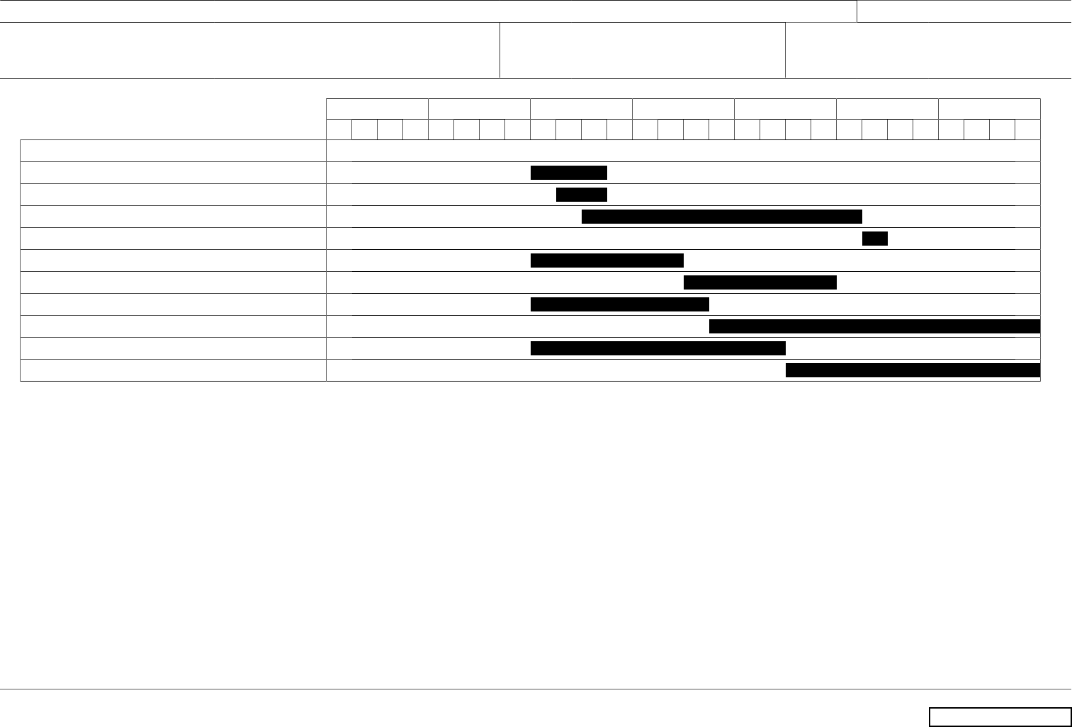
FY 2019 FY 2020 FY 2021 FY 2022 FY 2023 FY 2024 FY 2025
1 2 3 4 1 2 3 4 1 2 3 4 1 2 3 4 1 2 3 4 1 2 3 4 1 2 3 4
GPS IIIF
GSS 1 & 2 Subsystem Procurement & Build
GSS 1 & 2 Hardware Available
GSS 1&2 Integration
GSS 1&2 Delivered
GNST+ Subsystem Procurement & Build
GNST+ Integration
SV11 Subsystem Procurement & Build
SV11 System Integration & Test
SV12 Subsystem Procurement & Build
SV12 System Integration & Test
Volume 1 - 103
UNCLASSIFIED
PE 1203269SF: GPS III Follow-On (GPS IIIF)
UNCLASSIFIED
Air Force Page 8 of 8 R-1 Line #12
Exhibit R-4A, RDT&E Schedule Details: PB2021Air Force
Date: February 2020
Appropriation/Budget Activity
3620F / 5
R-1 Program Element (Number/Name)
PE 1203269SF / GPS III Follow-On (GPS
IIIF)
Project (Number/Name)
653170 / GPS IIIF
Schedule Details
Start End
Events by Sub Project Quarter Year Quarter Year
GPS IIIF
GSS 1 & 2 Subsystem Procurement & Build 1 2021 3 2021
GSS 1 & 2 Hardware Available 2 2021 3 2021
GSS 1&2 Integration 3 2021 1 2024
GSS 1&2 Delivered 2 2024 2 2024
GNST+ Subsystem Procurement & Build 1 2021 2 2022
GNST+ Integration 3 2022 4 2023
SV11 Subsystem Procurement & Build 1 2021 3 2022
SV11 System Integration & Test 4 2022 4 2025
SV12 Subsystem Procurement & Build 1 2021 2 2023
SV12 System Integration & Test 3 2023 4 2025
Volume 1 - 104
